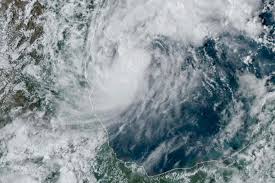
As of 8 AM Monday, the National Hurricane Center has upgraded Hurricane Milton to a major Category 4 storm, marking a significant escalation in its intensity. An eye wall has developed overnight, setting the stage for rapid intensification throughout the day.

A Hurricane Watch is now in effect for Florida’s Suncoast, indicating that tropical-storm-force winds may arrive within the next 48 hours. Residents are urged to finalize preparations to safeguard life and property, as wind speeds could reach 110 mph or more. However, there remains considerable uncertainty regarding the exact landfall location.
In addition to high winds, a storm surge of 8 to 12 feet is anticipated, accompanied by large and dangerous waves. A Storm Surge Watch is currently active, and officials warn that the timing of the surge relative to the tidal cycle can significantly impact flooding levels.
Rainfall is another critical concern, with projections estimating between 5 to 10 inches across the Florida Peninsula and the Keys, and localized totals potentially reaching up to 15 inches by Wednesday night. This deluge poses a serious risk of flash floods, urban flooding, and may lead to moderate to major river flooding in some areas.
Residents are advised to stay informed through local National Weather Service updates and to monitor conditions closely as Hurricane Milton approaches.